


Real Time Updates
Surfer rescued Thursday at Navarre Beach as Helene brought large swells
A surfer was rescued by Navarre Beach Lifeguards just west of the Navarre Beach Fishing Pier on Thursday, Sept. 26.
The surfer’s leash broke, disconnecting him from his board and leading to his need for rescue amongst the 12-to-14-foot waves. There were double red flags that day as Hurricane Helene made its approach.
Two surfers, Kerstan Chojnacki and Dave Wilson, helped the unnamed surfer while waiting for lifeguard assistance.
Austin Turnbull, the Beach Safety Division Chief and head of the Navarre Beach Lifeguards, told Navarre Press that the man rescued had become disoriented and his eyes were rolling in the back of his head. The man’s current condition is unknown at this time.
Helene lashes the South with wind and sheets of rain. Millions are without power
By Stephen Smith, Kate Payne and Heather Hollingsworth
Associated Press
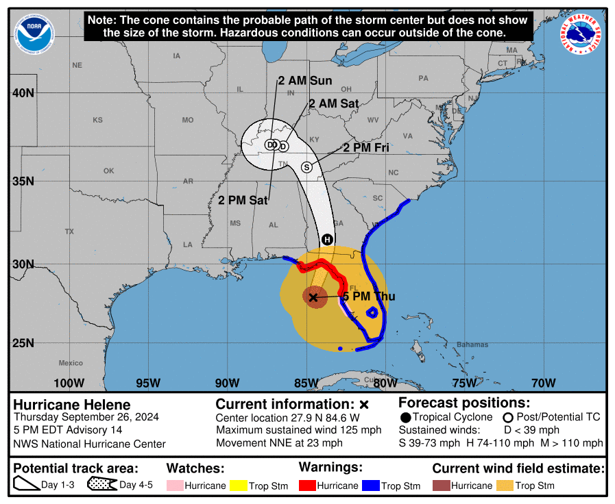
CRAWFORDVILLE, Fla. (AP) — Hurricane Helene roared ashore as a powerful Category 4 storm in a sparsely populated region of Florida, peeling the siding from buildings, trapping residents in rising floodwaters and knocking out power to millions of customers. At least five people were reported dead.
The storm made landfall late Thursday with maximum sustained winds of 140 mph (225 kph) in the rural Big Bend area, home to fishing villages and vacation hideaways where Florida’s Panhandle and peninsula meet.
Video on social media sites showed sheets of rain coming down and siding coming off buildings in Perry, Florida, near where the storm arrived. One local news station showed a home that was overturned.
First responders were out in boats early Friday to rescue people trapped by flooding in Citrus County, some 120 miles (193 kilometers) south of Perry.
“If you are trapped and need help please call for rescuers – DO NOT TRY TO TREAD FLOODWATERS YOURSELF,” the sheriff’s office warned in a Facebook post. Authorities said the water could contain live wires, sewage, sharp objects and other debris.
Nearly 4 million homes and businesses were without power Friday morning in Florida, Georgia and South Carolina, according to poweroutage.us, which tracks utility reports.
One person was killed in Florida when a sign fell on their car, and two people were reported killed in a possible tornado in south Georgia as the storm approached. Trees that toppled onto homes were blamed for deaths in Charlotte, North Carolina, and Anderson County, South Carolina.
The hurricane came ashore near the mouth of the Aucilla River on Florida’s Gulf Coast. That location was only about 20 miles (32 kilometers) northwest of where Hurricane Idalia hit last year at nearly the same ferocity and caused widespread damage.
As the hurricane’s eye passed near Valdosta, Georgia, a city of 55,000 near the Florida line, dozens of people huddled early Friday in a darkened hotel lobby. The wind whistled and howled outside.
Electricity was out, with hallway emergency lights, flashlights and cellphones providing the only illumination. Water dripped from light fixtures in the lobby dining area, and roof debris fell to the ground outside.
Fermin Herrera, 20, his wife and their 2-month-old daughter left their room on the top floor of the hotel, where they took shelter because they were concerned about trees falling on their Valdosta home.
“We heard some rumbling,” said Herrera, cradling the sleeping baby in a downstairs hallway. “We didn’t see anything at first. After a while the intensity picked up. It looked like a gutter that was banging against our window. So we made a decision to leave.”
In Thomas County, Georgia, where residents had been under a curfew, the sheriff’s office said it was extended until noon Friday.
“This curfew helps protect first responders and citizens of our community as conditions are still very hazardous. Please shelter in place,” the office posted online.
Helene is the third storm to strike the city in just over a year. Tropical Storm Debby blacked out power to thousands in August, while Hurricane Idalia damaged an estimated 1,000 homes in Valdosta and surrounding Lowndes County a year ago.
“I feel like a lot of us know what to do now,” Herrera said. “We’ve seen some storms and grown some thicker skins.”
Soon after it crossed over land, Helene weakened to a tropical storm, with its maximum sustained winds falling to 70 mph (110 kph). At 5 a.m., the storm was about 40 miles (65 kilometers) east of Macon, Georgia, and about 100 miles (165 kilometers) southeast of Atlanta, moving north at 30 mph (48 kph), the National Hurricane Center in Miami reported.
Forecasters expected the system to continue weakening as it moves into Tennessee and Kentucky and drops heavy rain over the Appalachian Mountains, with the risk of mudslides and flash flooding.
Even before landfall, the storm’s wrath was felt widely, with sustained tropical storm-force winds and hurricane-force gusts along Florida’s west coast. Water lapped over a road in Siesta Key near Sarasota and covered some intersections in St. Pete Beach. Lumber and other debris from a fire in Cedar Key a week ago crashed ashore in the rising water.
Beyond Florida, up to 10 inches (25 centimeters) of rain had fallen in the North Carolina mountains, with up to 14 inches (36 centimeters) more possible before the deluge ends, setting the stage for flooding that forecasters warned could be worse than anything seen in the past century.
“Please write your name, birthday, and important information on your arm or leg in a PERMANENT MARKER so that you can be identified and family notified,” the sheriff’s office in mostly rural Taylor County warned those who chose not to evacuate in a Facebook post, the dire advice similar to what other officials have dolled out during past hurricanes.
School districts and multiple universities canceled classes. Airports in Tampa, Tallahassee and Clearwater were closed Thursday, while cancellations were widespread elsewhere in Florida and beyond.
A day before hitting the U.S., Helene swamped parts of Mexico’s Yucatan Peninsula, flooding streets and toppling trees as it brushed the resort city of Cancun and passed offshore. In western Cuba, Helene knocked out power to more than 200,000 homes and businesses as it brushed past the island.
At one point, forecasters feared that hurricane conditions could extend as far as 100 miles (160 kilometers) north of the Georgia-Florida line. Overnight curfews were imposed in many cities and counties in south Georgia.
“This is one of the biggest storms we’ve ever had,” Georgia Gov. Brian Kemp said.
For Atlanta, Helene could be the worst strike on a major Southern inland city in 35 years, said University of Georgia meteorology professor Marshall Shepherd.
Helene is the eighth named storm of the Atlantic hurricane season, which began June 1. The National Oceanic and Atmospheric Administration has predicted an above-average Atlantic hurricane season this year because of record-warm ocean temperatures.
Three deaths attributed to Hurricane Helene
Sept. 26, 2024 | 11 p.m.
Three people have died from the impacts of Hurricane Helene, according to a report from the Associated Press.
Florida Gov. Ron DeSantis said one of the deaths was in Tampa, where a person driving across Interstate 4 was killed when a sign fell on their vehicle. DeSantis said people need to hunker down until the storm passes.
Two people were also killed in a possible tornado in Alamo, Georgia, according to the Associated Press.
DeSantis’ full press conference is below:
Governor Ron DeSantis Gives Update #5 as Hurricane Helene Makes Landfall https://t.co/WEociHfQlZ
— Ron DeSantis (@GovRonDeSantis) September 27, 2024
Hurricane Helene makes landfall near Perry
Sept. 26, 2024 | 10:24 p.m.
The National Hurricane Center said that at 10:20 p.m. CT, Hurricane Helene made landfall as a category four hurricane in Florida’s Big Bend region.
The eye was about 10 miles west-southwest of Perry. The maximum sustained winds of the storm were 140 miles per hour.

Santa Rosa District Schools are open on Friday
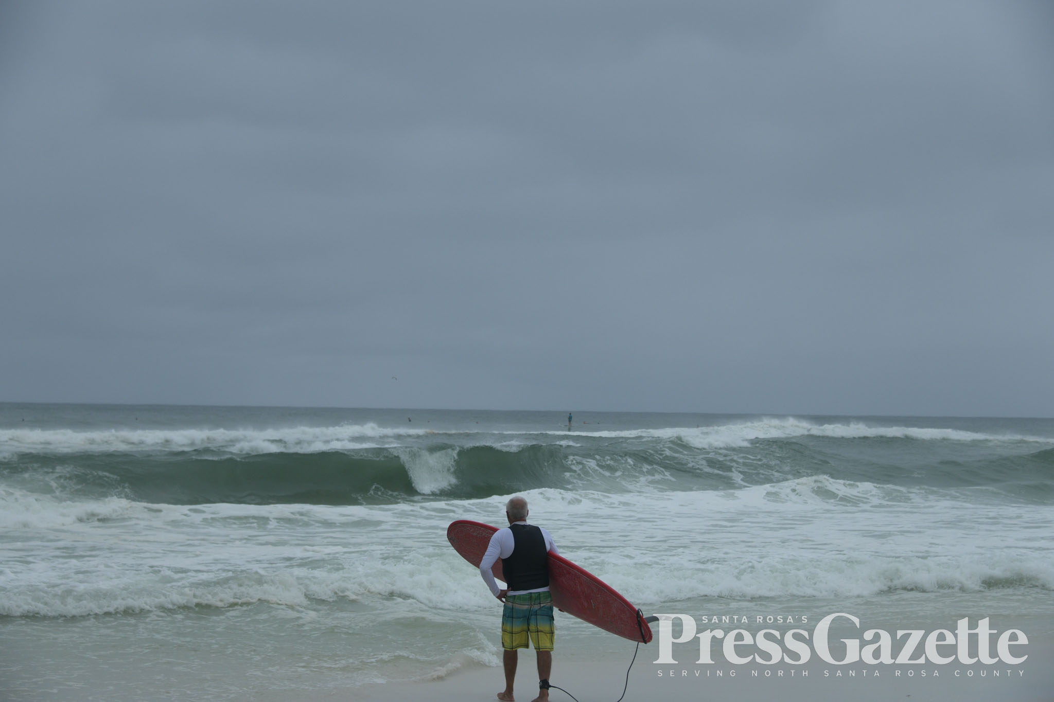
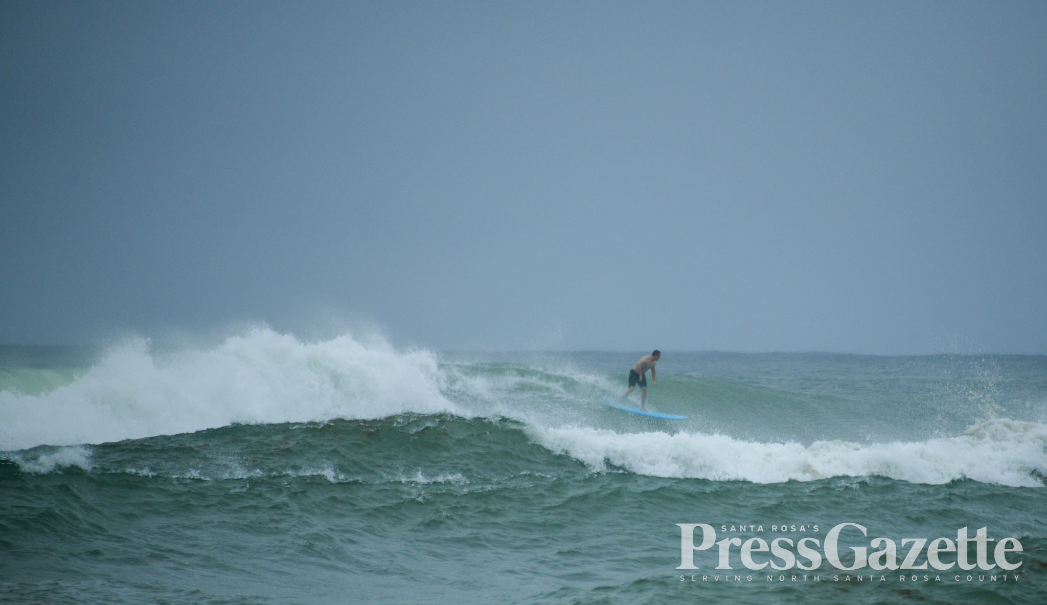
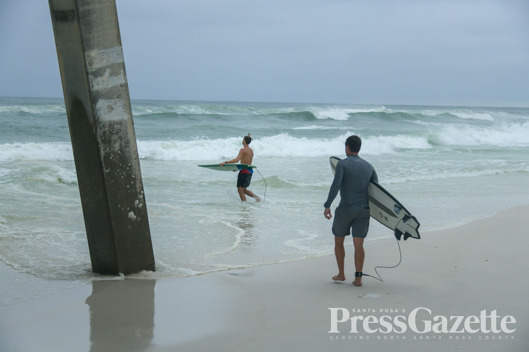
PHOTOS: Surfers at Navarre Beach take advantage of large swells from Hurricane Helene
Sept. 25, 2024 | 4:45 p.m.
As Hurricane Helene neared landfall in Florida, surfers were taking advantage of the large swells at Navarre Beach on Thursday, Sept. 26. Photos by Hansen Hasenberg.

Hurricane Helene nears landfall, likely as a category four storm
Sept. 25, 2024 | 4 p.m.
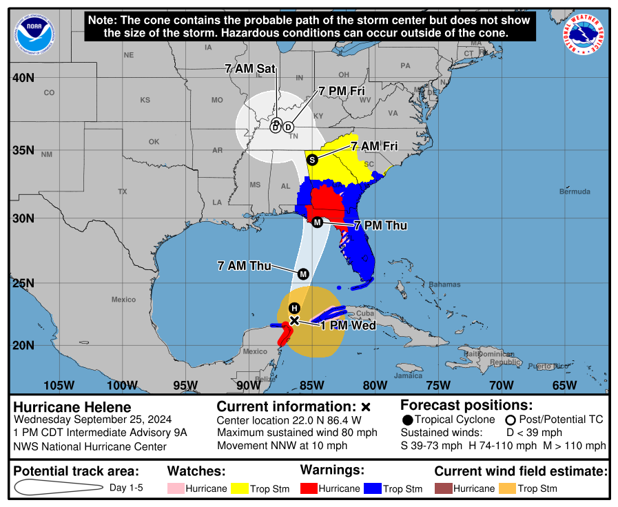
Hurricane Helene is nearing landfall in Florida’s big bend area as a category three storm. The 4 p.m. update from the National Hurricane Center notes that Helene is likely to make landfall as a category four hurricane.
Maximum sustained winds were at 125 miles per hour, with higher gusts. To reach category four status, Helene will need 130 mile per hour winds.
Santa Rosa County is expected to have zero impacts inland, though double red flags are flying at Navarre Beach. A wind advisory remains in effect until midnight.
Milton to close Clyde L. Gracey Community Center & Sportsplex due to Hurricane Helene
The city of Milton announced that all activities at the Clyde L. Gracey Community Center & Sportsplex, including youth sports, are canceled after 3 p.m. on Thursday.
The city also said the LEAP Committee meeting scheduled for Thursday has been canceled.
All other city operations will continue as scheduled at this time.
“We will continue to closely monitor the storm’s progress and provide updates as needed,” the city said in a press release. “Public Safety remains a top priority, and we encourage all residents to stay informed and prepared.”
Hurricane Helene is expected to make landfall in Florida’s big bend region later this evening.
FPL mobilizes crews ahead of Hurricane Helene
Sept. 26, 2024 | 11:06 a.m.
Florida Power & Light said it is ready to respond at Hurricane Helene approaches the state.
FPL said it has assembled a restoration workforce of thousands and is pre-positioning crews, equipment and supplies to restore power safely and as quickly as possible. Pictures on social media show a large parking lot of FPL trucks in Pensacola, seemingly staging for deployment after Helene hits Thursday night.
“Helene is expected to be a powerful storm with widespread impacts,” said FPL President and CEO Armando Pimentel in a FPL press release. “I want to assure customers that FPL is ready to respond. We have a restoration workforce strategically positioned and ready to restore power quickly. We will not stop until every customer is restored.”
As soon as it is safe to do so, FPL said it will begin the restoration process while field crews complete a full damage assessment.
Many in Santa Rosa County on standby to assist hard-hit areas from Hurricane Helene
Sept. 26, 2024 | 10:37 a.m.
With Hurricane Helene hitting to the east of Santa Rosa County, many in the county are getting ready to help with recovery in harder hit areas of Florida.
The storm is expected to make landfall in Florida’s big bend area around 7 p.m. Thursday night, and many are planning to assist.
Here’s a list of what we know so far:
- Santa Rosa County’s Emergency Management team will be deploying to Liberty County Friday morning. The team includes Public Information Officer Sarah Whitfield, Emergency Management Director Tom Lloyd and Emergency Management Plans Chief Kevin Riley.
- Two 911 dispatchers will head to either Bay County or Franklin County, depending on the need, according to the county.
- Holley-Navarre Fire District and Avalon Fire Rescue are on standby to deploy but have not been given an official assignment yet, according to the county.
- The Santa Rosa County Sheriff’s Office is planning to deploy, but it depends on access to the county assigned.
- City of Milton Public Information Officer Bethany Anderson said the city is “is committed to providing support where we can, in alignment with our resources and capacity.” Anderson said any assistance will be coordinated through the state.
Santa Rosa County may not see much rain from Helene
Sept. 26, 2024 | 8:45 a.m.
It’s a nice day in Santa Rosa County, making it hard to believe a hurricane will make landfall to our east.
Hurricane Helene, now a category two storm, is expected to make landfall around 7 p.m. tonight in Florida’s big bend. The impact on Santa Rosa County is minimal, even to the point that little rainfall is forecasted. Here’s the latest updates from a local perspective:
- Rainfall totals shifted overnight. Previously, Santa Rosa County was looking at somewhere between 2 to 4 inches of rain, but now it appears it could be a relatively dry day. There’s a 50% chance of rain today, according to the National Weather Service. The latest rainfall totals from the National Hurricane Center show Santa Rosa County in a dry area.
- A wind advisory remains in place from noon on Thursday until midnight tonight.
- As the storm makes its way through the Gulf, 64 of Florida’s 67 counties remain under a hurricane or tropical storm warning, but Santa Rosa County is not among them.
64 of 67 Florida counties under tropical storm or hurricane warning, but not Santa Rosa
Sept. 25, 2024 | 10:01 p.m.
The National Hurricane Center released its 10 p.m. update on Hurricane Helene, which continues to show the eye of the storm hitting in Florida’s “big bend” area.
The storm is expected to make landfall in less than 24 hours, around 7 p.m. CT on Thursday.
In all 64 of Florida’s 67 counties are under a tropical storm or hurricane warning. Santa Rosa, Escambia and Okaloosa County are the three excluded.
Here are some quick updates from a Santa Rosa County perspective:
- A wind advisory remains in effect for Santa Rosa County from noon on Thursday until midnight. The wind is expected to blow between 15 and 25 miles per hour with gusts up to 40 miles per hour.
- Barring a significant, last minute change of direction, Santa Rosa County is not expected to have major impacts from the storm. Wind and several inches of rain are expected. Computer models have been consistent on the path of the storm for several days.
- Santa Rosa District Schools are closed on Thursday, a reversal from an early afternoon decision. The wind advisory was noted as the reason why the district changed its mind.
Santa Rosa County under a wind advisory for Thursday as Helene makes its way through Gulf
Santa Rosa County has been added to a wind advisory by the National Weather Service.
On Wednesday morning, only the coastal areas of Santa Rosa County were put under the wind advisory, but now the entire county has been added.
The path of Hurricane Helene, updated at 4 p.m. CT, still remains far to Santa Rosa County’s east, aimed toward Florida’s big bend area.
Here’s information on the wind advisory from NWS:
...WIND ADVISORY IN EFFECT FROM NOON THURSDAY TO MIDNIGHT CDT
THURSDAY NIGHT...

* WHAT...North winds 15 to 25 mph with gusts up to 40 mph expected
  becoming northwest.

* WHERE...In Alabama, Covington, Mobile Central, Baldwin
  Central, Mobile Coastal and Baldwin Coastal Counties. In
  Florida, Escambia Inland, Escambia Coastal, Santa Rosa Inland
  and Okaloosa Inland Counties.

* WHEN...From noon Thursday to midnight CDT Thursday night.

* IMPACTS...Gusty winds could blow around unsecured objects.
  Tree limbs could be blown down and a few power outages may
  result.

PRECAUTIONARY/PREPAREDNESS ACTIONS...

Use extra caution when driving, especially if operating a high
profile vehicle. Secure outdoor objects.
Santa Rosa County schools reverse course, schools out Thursday
1 p.m. update: Latest path update on Hurricane Helene
UPDATE: Since this post, Santa Rosa County District Schools has reversed course and canceled school on Thursday, Sept. 26.
Sept. 25, 2024 | 1:34 p.m.
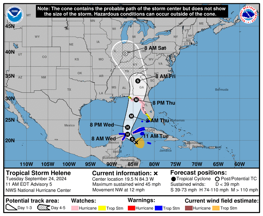
The National Hurricane Center released its 1 p.m. CT update on Hurricane Helene, providing the latest track for the storm, which remains relatively unchanged.
Helene is still projected to make landfall at 6 p.m. CT Thursday as a major hurricane.
Here are the important highlights for Santa Rosa County:
- The storm’s track still remains to Santa Rosa County’s east, to the point that Santa Rosa County is not under any watches or warnings. Tropical Storm Warnings go as far as the Okaloosa/Walton County line.
- No watches or warnings were changed with the latest advisory.
- Santa Rosa County District Schools announced that school will be held Thursday on a normal schedule. However, there will be no afterschool activities, events, or athletics on Thursday, September 26. The school district expects a normal day on Friday.
- Santa Rosa County’s coastal areas are under a wind advisory from noon on Thursday until 6 a.m. on Friday, with northwest winds of 20 to 30 miles per hour and gusts of 45 miles per hour expected. The locations impacted include Bagdad, Gulf Breeze, Navarre, Destin, Eglin Air Force Base, Fort Walton Beach, Niceville, Seminole, Valparaiso and Wright.
- Current estimates from the National Weather Service predict 2 to 4 inches of rain for Santa Rosa County.
10 a.m. Helene update: Tropical storm warning extended, still doesn’t include Santa Rosa County
Sept. 25, 2024 | 10:43 a.m.
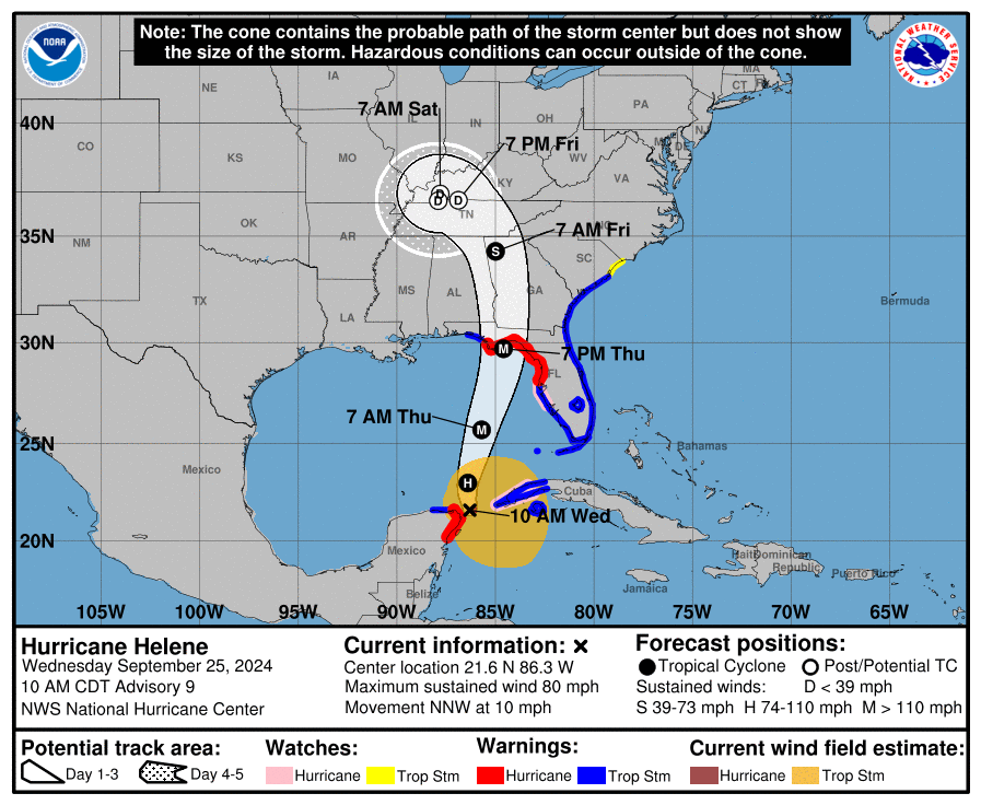
The National Hurricane Center provided its latest update on now Hurricane Helene on Wednesday morning at 10 a.m.
Little change is shown in the path of the storm, which still has the eye going east of Santa Rosa County. There are currently no watches or warnings for Santa Rosa County.
However, the storm has strengthened, now becoming hurricane with sustained winds of about 80 miles per hour, according to the National Weather Service. The Tropical Storm warning was extended west to the Okaloosa County/Walton County line.
The storm is expected to make landfall in Florida’s big bend region around 7 p.m. on Thursday.
Helene expected to become hurricane by Wednesday evening
Sept. 24, 2024 | 10:22 p.m.
The National Hurricane Center published its final update of the day at 10 p.m., with little change in the projected path for Tropical Storm Helene.
Here’s the quick notes, for anyone playing catch up at this point:
- The storm is still just southeast of the Yucatan Peninsula, but it is expected to become a hurricane by Wednesday evening as it begins its movement into and through the Gulf of Mexico.
- Helene’s eye is expected to hit Florida’s “big bend” area as a major hurricane.
- Tropical Storm and Hurricane warnings have been issued for much of Florida’s coast, but Santa Rosa County is not included.
- For what it’s worth, the projected time of landfall has moved up to 6 p.m. CT on Thursday. Earlier today, it was 7 p.m. CT. However, it’s important to note that the exact timing is still up in the air at this point.
- Helene is expected to move quickly after making landfall. By Friday at 6 a.m. CT, the eye is projected to be in northwest Georgia.
What it means for Santa Rosa County:
- The storm remains to our east and current forecasting has Santa Rosa County receiving 2 to 4 inches of rain.
- If the current forecast remains intact, the worst of the conditions would be far east of Santa Rosa County.
- Stay weather aware, just in case of changes in the forecast in the final few days.
4 p.m. update: Helene’s path remains relatively unchanged as hurricane warnings issued to our east
Sept. 24, 2024 | 4 p.m.
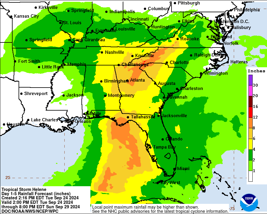
The 4 p.m. update from the National Hurricane Center on Tropical Storm Helene showed little change in the expected path of the storm, which is still trending toward Florida’s “big bend.”
The storm’s eye remains east of Santa Rosa County. The storm is expected to make landfall Thursday night, with the exact timing still to be determined.
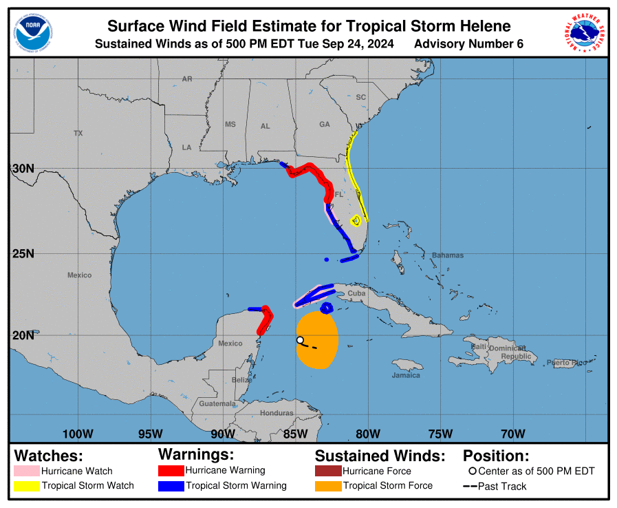
Here’s part of the latest advisory from the National Hurricane Center.
At 500 PM EDT (2100 UTC), the center of Tropical Storm Helene was
located near latitude 19.7 North, longitude 84.7 West.  Helene is
moving toward the west-northwest near 12 mph (19 km/h).  A turn
toward the northwest is expected tonight, followed by a general
northward motion beginning on Wednesday and continuing through
Friday.  On the forecast track, the center of Helene will pass near
the northeastern coast of the Yucatan Peninsula on Wednesday, move
across the eastern Gulf of Mexico on Wednesday and Thursday, and
reach the Big Bend coast of Florida late Thursday.

Maximum sustained winds have increased to near 50 mph (85 km/h)
with higher gusts.  Additional strengthening is forecast, and
Helene is expected to become a hurricane on Wednesday.  The storm
is forecast to rapidly strengthen over the eastern Gulf of Mexico
and become a major hurricane on Thursday.

Tropical-storm-force winds extend outward up to 175 miles (280 km)
to the east of the center.
Hurricane warnings and tropical storm warnings have been issued for areas to our east.
SUMMARY OF WATCHES AND WARNINGS IN EFFECT:

A Storm Surge Warning is in effect for...
* Indian Pass southward to Flamingo
* Tampa Bay
* Charlotte Harbor

A Hurricane Warning is in effect for...
* Anclote River to Mexico Beach, Florida
* Cabo Catoche to Tulum, Mexico

A Hurricane Watch is in effect for...
* Cuban province of Pinar del Rio
* Englewood to Anclote River, including Tampa Bay

A Tropical Storm Warning is in effect for...
* Dry Tortugas
* Lower and Middle Florida Keys west of the Channel 5 Bridge
* Flamingo to Anclote River, including Tampa Bay
* Rio Lagartos to Tulum, Mexico
* Cuban provinces of Artemisa, Pinar del Rio, and the Isle of Youth

A Tropical Storm Watch is in effect for...
* Lake Okeechobee
* Palm Beach/Martin County Line northward to the Savannah River
School district says it continues to track Tropical Storm Helene
“Santa Rosa County District Schools Officials have been in close contact again today with the Santa Rosa Emergency Management Office and National Weather Service of Mobile.
Based on today’s updates and progression of this storm now trending further east, school WILL BE in session tomorrow, Wednesday, September 25. ***We will provide another update tomorrow regarding decisions for school on Thursday, September 26. ***
Please know, the safety of our students and staff continues to be our top priority. To stay informed with the most recent information from the National Hurricane Center, please click the link below. https://www.nhc.noaa.gov/Stay tuned to our social media outlets and website for any additional updates during and/or after the storm if necessary. We hope you and your family stay safe during this time!”
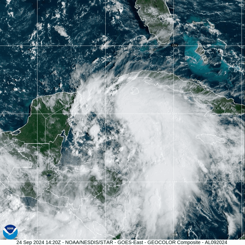
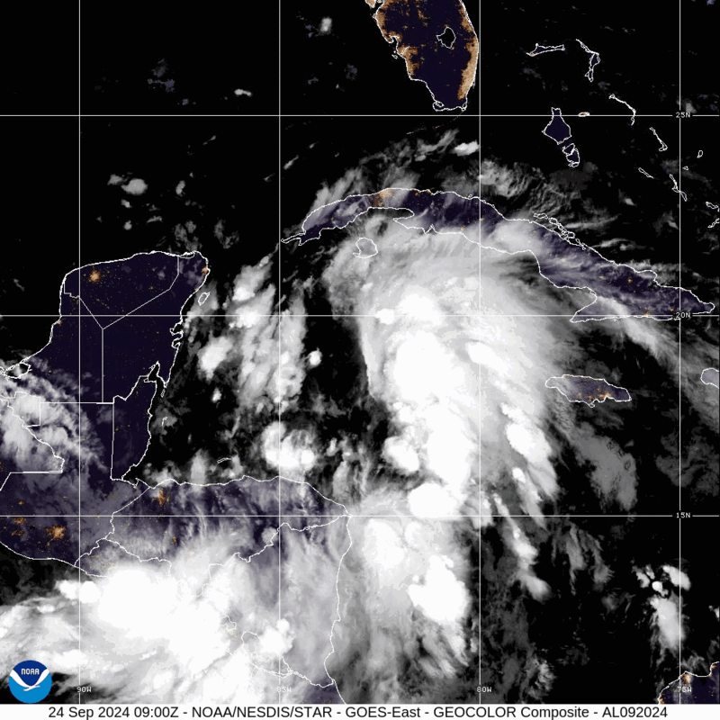
Tropical Storm Helene forms in the Caribbean Sea
Sept. 24, 2024 | 12:10 p.m.
No longer Projected Tropical Cyclone Nine, Tropical Storm Helene has formed over the northwestern Caribbean Sea.
The projected path of the storm still shows it going east of Santa Rosa County, hitting in Florida’s “big bend,” making landfall as a major hurricane at 7 p.m. CT on Thursday.
Current rainfall projections from the National Hurricane Center show Santa Rosa County receiving somewhere between 2 and 4 inches of rain.
The NHC expects the storm to strengthen as it makes its way through the Caribbean Sea. Here’s information from their latest advisory:
A northward to north-northeastward motion at a faster forward speed
is expected on Wednesday and Thursday.  On the forecast track, the
center of Helene will move across the far northwestern Caribbean
Sea through tonight, and then move across the eastern Gulf of
Mexico Wednesday and Thursday, potentially reaching the Gulf coast
of Florida late Thursday.

Data from an Air Force Reserve Hurricane Hunter aircraft indicate
that the system has acquired a well-defined center of circulation,
and maximum sustained winds have increased to near 45 mph (75 km/h)
with higher gusts.  Additional strengthening is forecast, and
Helene is expected to become a hurricane on Wednesday.  Continued
strengthening is anticipated after that time, and Helene could
become a major hurricane on Thursday.
Early morning update shrinks cone of uncertainty, storm still east of Santa Rosa County
The storm is expected to hit Florida’s big bend area, where it’s projected to be a major hurricane.
Here’s the latest information in the National Hurricane Center’s advisory, including where hurricane and tropical storm watches have been issued (which again doesn’t include Santa Rosa County):
A Storm Surge Watch has been issued from Indian Pass Florida
southward to Bonita Beach Florida, including Tampa Bay and
Charlotte Harbor.

A Hurricane Watch has been issued for the Gulf Coast of Florida
from Englewood northward and westward to Indian Pass, including
Tampa Bay.

A Tropical Storm Watch has been issued for the Gulf Coast of
Florida from Indian Pass to the Walton/Bay County Line and from
north of Bonita Beach to south of Englewood.

SUMMARY OF WATCHES AND WARNINGS IN EFFECT:

A Storm Surge Watch is in effect for...
* Indian Pass southward to Flamingo
* Tampa Bay
* Charlotte Harbor

A Hurricane Watch is in effect for...
* Cabo Catoche to Tulum, Mexico
* Cuban province of Pinar del Rio
* Englewood to Indian Pass
* Tampa Bay

A Tropical Storm Warning is in effect for...
* Grand Cayman
* Rio Lagartos to Tulum, Mexico
* Cuban provinces of Artemisa, and Pinar del Rio, and the Isle of
Youth

A Tropical Storm Watch is in effect for...
* Dry Tortugas
* Lower Keys west of the Seven Mile Bridge
* Flamingo to south of Englewood
* West of Indian Pass to Walton Bay County line

A Storm Surge Watch means there is a possibility of life-
threatening inundation, from rising water moving inland from the
coastline, in the indicated locations during the next 48 hours.
For a depiction of areas at risk, please see the National Weather
Service Storm Surge Watch/Warning Graphic, available at
hurricanes.gov.

A Tropical Storm Warning means that tropical storm conditions are
expected somewhere within the warning area, in this case within
the next 24 to 36 hours.

A Hurricane Watch means that hurricane conditions are possible
within the watch area.  A watch is typically issued 48 hours
before the anticipated first occurrence of tropical-storm-force
winds, conditions that make outside preparations difficult or
dangerous.

A Tropical Storm Watch means that tropical storm conditions are
possible within the watch area, generally within 48 hours.

Interests elsewhere along the northeastern Gulf Coast, including the
Florida Panhandle and the Florida west Gulf coast, should monitor
the progress of this system.  Additional watches or warnings will
likely be required today.
7 p.m. update: Latest advisory provides latest track of Potential Tropical Cyclone Nine
The path still takes it toward Florida’s “big bend,” meaning the eye is projected to go east of Santa Rosa County. However, much uncertainty remains about the storm’s future path. It’s projected landfall is Thursday afternoon.
The National Hurricane Center said the following as part of its advisory:
“Interests along the northeastern Gulf Coast, including the Florida Panhandle and the Florida west coast, should monitor the progress of this system. Additional watches or warnings will likely be required tonight and Tuesday.”
Santa Rosa County District Schools ‘actively monitoring the weather’
Newest update shows latest on projected path for storm
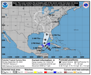
September 23, 2024 | 5 p.m.
The National Hurricane Center released an update on Tropical Cyclone Nine, likely-soon-to-be Hurricane Helene.
The storm is now projected to be a major hurricane when it hits land. The storm’s eye is still projected to hit east of Santa Rosa County.
Santa Rosa County announces locations where sand is available
September 23, 2024 | 3:30 p.m.
Santa Rosa County’s public works department has sand available on a first-come, first-served basis at the following locations:
– The corner of Leisure St. and Citrus Dr. in Navarre
– Tiger Point Park in Gulf Breeze (1370 Tiger Park Ln.)
– Pace Fire-Rescue in Pace (4773 Pace Patriot Blvd.)
– The corner of Pine Forest Rd. and Carroll Rd. in Milton
– Residents must provide their own sandbags and shovel. Bags can be purchased at many local hardware stores.
Santa Rosa County said for more information on how to make and use sandbags, visit the Federal Alliance for Safe Homes (www.flash.org). While sandbags can help mitigate to an extent, buying flood insurance is the best protection against flood loss.
DeSantis declares emergency as hurricane looms
By Jim Turner and Tom Urban
The system, expected to be named Helene, was forecast Monday to reach northern Florida this week with life-threatening storm surge and winds that will cause widespread power outages.
“It’s going to be a hurricane, at least a Cat 1 (Category 1), possibly a Cat 2. Will it be stronger than that? That remains to be seen,” said Felecia Bowser, meteorologist in charge of the National Weather Service Tallahassee. “Those types of clarifications are going to be coming in the next day or two, where we can see if we are going to be faced with a major hurricane.”
The National Hurricane Center warned that while the most likely path of the system shows landfall in North Florida’s Big Bend region or in the Panhandle, storm surge, wind, and rain will affect areas well away from the center of the storm, particularly to the east of its eye.
“The hurricane regional models highlight the potential for strengthening to major hurricane intensity,” the hurricane center said in a mid-day update Monday.
A separate tracking map by the meteorology company AccuWeather had the storm rapidly intensifying while over the Gulf of Mexico to sustained winds topping 130 mph — Category 4 on the Saffir-Simpson Hurricane Wind Scale — and to make landfall with Category 3 strength of 111 mph to 129 mph sustained winds.
“The combination of deep warm water (ocean heat content) and low disruptive breezes (wind shear), should assist in rapid strengthening when over the Gulf of Mexico from Wednesday to Thursday,” AccuWeather Chief On-Air Meteorologist Bernie Rayno said in a statement. “Most likely, the storm will create its own environment and bring a surge in moisture to the currently dry air over the Gulf.”
AccuWeather noted that the storm could move into the Florida peninsula on Thursday, with a higher probability of landfall in the Panhandle late Thursday.
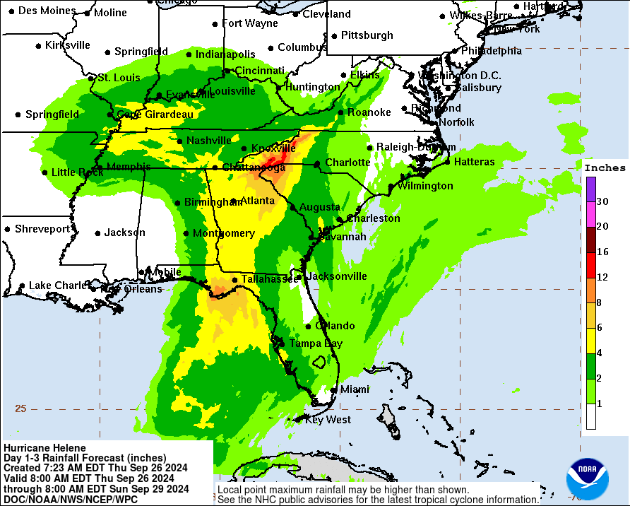
The area where the storm makes landfall could see 8 to 12 inches of rain. Parts of North Florida were battered last year by Hurricane Idalia and last month by Hurricane Debby — both of which made landfall in the Big Bend’s Taylor County.
DeSantis’ order placed Division of Emergency Management Executive Director Kevin Guthrie in charge of the state’s response, including coordinating efforts with utility companies, neighboring states and the federal government.
DeSantis’ order also activated the Florida National Guard and Florida State Guard.
The order included Alachua, Bay, Bradford, Calhoun, Charlotte, Citrus, Collier, Columbia, Dixie, Escambia, Franklin, Gadsden, Gilchrist, Gulf, Hamilton, Hernando, Hillsborough, Holmes, Jackson, Jefferson, Lafayette, Lee, Leon, Levy, Liberty, Madison, Manatee, Marion, Monroe, Okaloosa, Pasco, Pinellas, Santa Rosa, Sarasota, Sumter, Suwannee, Taylor, Union, Wakulla, Walton, and Washington counties.
The city of Tallahassee opened eight sandbag-distribution sites Monday, warning impacts were possible before daybreak Thursday.
The storm system is expected to make a gradual northwestern turn during the next day as the center passes through the Yucatan Channel and into the southern Gulf of Mexico.
From there, conditions in the Gulf of Mexico are favorable for significant strengthening, the hurricane center said.
In addition to Idalia and Debby making landfall in the Big Bend, Hurricane Michael brought 160 mph sustained winds near Mexico Beach in October 2018 and caused widespread damage in the Panhandle.
UPDATE 9-23-23 | 1PM
Check this page for real time hurricane updates and information
Latest News

Surfer rescued Thursday at Navarre Beach as Helene brought large swells
A surfer was rescued by Navarre Beach Lifeguards just west of the Navarre Beach Fishing Pier on Thursday, Sept. 26.

Florida starts recovery after monster storm
Tallahassee – Rescue and recovery efforts were underway Friday morning in North Florida’s Big Bend region and other areas of the state after the Category 4 Hurricane Helene made landfall Thursday night in Taylor County.

Helene lashes the South with wind and sheets of rain. Millions are without power
CRAWFORDVILLE, Fla. (AP) — Hurricane Helene roared ashore as a powerful Category 4 storm in a sparsely populated region of Florida, peeling the siding from buildings, trapping residents in rising floodwaters and knocking out power to millions of customers. At least five people were reported dead.

Three deaths attributed to Hurricane Helene
Sept. 26, 2024 | 11 p.m. Three people have died from the impacts of Hurricane Helene, according to a report from the Associated Press. Florida Gov. Ron DeSantis said one of the deaths was in Tampa, where a person driving across Interstate 4 was killed when a sign fell on their vehicle. DeSantis said people […]
Hurricane Helene makes landfall near Perry
The National Hurricane Center said that at 10:20 p.m. CT, Hurricane Helene made landfall as a category four hurricane in Florida’s Big Bend region.

Santa Rosa District Schools are open on Friday
Santa Rosa District Schools will be open on Friday, Sept. 27.

PHOTOS: Surfers at Navarre Beach take advantage of large swells from Hurricane Helene
Sept. 25, 2024 | 4:45 p.m. As Hurricane Helene neared landfall in Florida, surfers were taking advantage of the large swells at Navarre Beach on Thursday, Sept. 26. Photos by Hansen Hasenberg.

Hurricane Helene nears landfall, likely as a category four storm
Hurricane Helene is nearing landfall in Florida’s big bend area as a category three storm. The 4 p.m. update from the National Hurricane Center notes that Helene is likely to make landfall as a category four hurricane.

Milton to close Clyde L. Gracey Community Center & Sportsplex due to Hurricane Helene
The city of Milton announced that all activities at the Clyde L. Gracey Community Center & Sportsplex, including youth sports, are canceled after 3 p.m. on Thursday.

Helene ‘moving fast’ before Thursday night landfall
Tallahassee – Gov. Ron DeSantis warned time is “running out quickly” for people to prepare for large, life-threatening Hurricane Helene, which was already a Category 2 storm Thursday morning as it raced toward making landfall on North Florida’s Gulf Coast.

Be Prepared by Being Informed
Hurricanes are massive storm systems that form over ocean water and often move toward land. Hurricanes bring high winds, heavy rain, storm surge (rise in water level), flooding and tornadoes. These storms are dangerous and can cause damage to places far inland.
Prepare now so you can stay safe.