News, stormcenter, stormcenterupdate
Early morning update shrinks cone of uncertainty, storm still east of Santa Rosa County
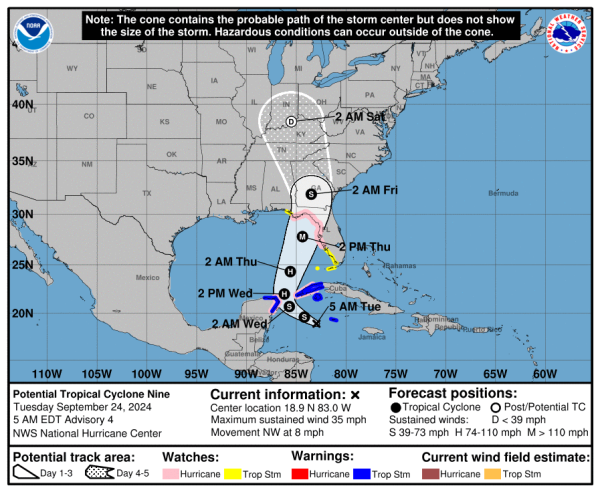
The early morning update on Potential Cyclone Nine, expected to form into Hurricane Ilene in the days ahead, shrunk the cone of uncertainty, leaving the center of the storm far east of Santa Rosa County.

The storm is expected to hit Florida’s big bend area, where it’s projected to be a major hurricane.
Here’s the latest information in the National Hurricane Center’s advisory, including where hurricane and tropical storm watches have been issued (which again doesn’t include Santa Rosa County):
A Storm Surge Watch has been issued from Indian Pass Florida
southward to Bonita Beach Florida, including Tampa Bay and
Charlotte Harbor.

A Hurricane Watch has been issued for the Gulf Coast of Florida
from Englewood northward and westward to Indian Pass, including
Tampa Bay.

A Tropical Storm Watch has been issued for the Gulf Coast of
Florida from Indian Pass to the Walton/Bay County Line and from
north of Bonita Beach to south of Englewood.

SUMMARY OF WATCHES AND WARNINGS IN EFFECT:

A Storm Surge Watch is in effect for...
* Indian Pass southward to Flamingo
* Tampa Bay
* Charlotte Harbor

A Hurricane Watch is in effect for...
* Cabo Catoche to Tulum, Mexico
* Cuban province of Pinar del Rio
* Englewood to Indian Pass
* Tampa Bay

A Tropical Storm Warning is in effect for...
* Grand Cayman
* Rio Lagartos to Tulum, Mexico
* Cuban provinces of Artemisa, and Pinar del Rio, and the Isle of
Youth

A Tropical Storm Watch is in effect for...
* Dry Tortugas
* Lower Keys west of the Seven Mile Bridge
* Flamingo to south of Englewood
* West of Indian Pass to Walton Bay County line

A Storm Surge Watch means there is a possibility of life-
threatening inundation, from rising water moving inland from the
coastline, in the indicated locations during the next 48 hours.
For a depiction of areas at risk, please see the National Weather
Service Storm Surge Watch/Warning Graphic, available at
hurricanes.gov.

A Tropical Storm Warning means that tropical storm conditions are
expected somewhere within the warning area, in this case within
the next 24 to 36 hours.

A Hurricane Watch means that hurricane conditions are possible
within the watch area.  A watch is typically issued 48 hours
before the anticipated first occurrence of tropical-storm-force
winds, conditions that make outside preparations difficult or
dangerous.

A Tropical Storm Watch means that tropical storm conditions are
possible within the watch area, generally within 48 hours.

Interests elsewhere along the northeastern Gulf Coast, including the
Florida Panhandle and the Florida west Gulf coast, should monitor
the progress of this system.  Additional watches or warnings will
likely be required today.


