








Santa Rosa County Public Safety Director Tom Lloyd said the county expects local impacts — rain, wind and storm surge — to begin Friday and worsen as the day continues into Saturday morning.
Isaias, as of 4:30 p.m. Wednesday, is 500 miles south-southwest of the mouth of the Mississippi River and moving east-northeast at 8 mph. The storm has maximum sustained winds of 65 mph.
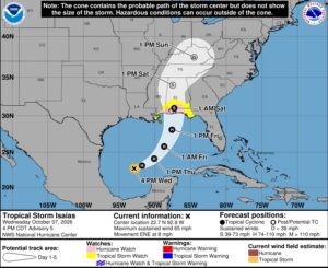
The National Hurricane Center’s projection is that it will make landfall Friday as a hurricane.
County officials are discussing evacuation notices. If forecasts do pan out, with up to a 7-foot surge and 20 to 25-foot breakers, the county will recommend evacuations for low-lying areas.
A forecast of 25-foot breakers refers to large waves expected to break as they approach shallow water near the coast. It does not mean the storm surge itself will be 25 feet high.
“I would have plans in place now to be able to evacuate if you are concerned about it,” Lloyd said.
He urged residents who decide to leave to go Thursday night rather than wait until Friday morning. Evacuees only need to travel tens of miles away, not hundreds, to avoid the storm’s impact.
The county typically starts with voluntary and “strongly recommended” evacuations for areas that historically flood or are forecast to see dangerous water levels, Lloyd said. He warned that emergency crews may not be able to reach people during the storm.
“We may not be able to get to you until after the storm subsides,” he added.
Lloyd said the county focuses on areas south of Interstate 10, which often sit near sea level and have little to slow the wind. Those areas include Navarre, Navarre Beach, Midway, Garcon Point, Holly and Gulf Breeze, and even shoreline fronting Escambia and Blackwater bays.
Lloyd also warned of flooding, especially as southern Santa Rosa County is still recovering from 22 inches of rain over the past weekend. He urged drivers not to drive through flooded roads.
Residents can look up their evacuation and flood zones using the Know Your Zone map on the Emergency Management section of the county’s website.
The county’s emergency operations center is in a monitoring phase and will activate as the week progresses. Officials are discussing shelter openings, and schools will be closed Oct. 9.
Lloyd said he had not seen anything on lifting tolls for the Garcon Point Bridge as of Wednesday. He said tolls would likely be suspended if an evacuation order is issued. If traffic is a concern, officials will look to make both lanes northbound only.
Residents who are stocking up should buy only what they need.
“We do not want people to panic. But if you do need gas, go get gas. If you need groceries, purchase groceries. But there is no reason to go to the grocery store and wipe out an entire row,” he said.
He also encouraged residents to help neighbors who may need a hand putting up storm shutters or securing loose objects.
Lloyd, who is in his 20th year with the county, cautioned residents against comparing Isaias with past storms such as Ivan, Dennis, Sally or Opal.
“Every storm is different. Every storm has similar hazards, but those hazards present themselves differently in every storm,” he said. “We don’t want you to be fearful. We just want you to be prepared.”
Residents who cannot evacuate on their own because of transportation or other needs can call the county’s Citizen Information Line at 850-983-4636 to be connected with resources.